The British Geotechnical Association (BGA) is the principal
association for geotechnical engineers in the United Kingdom.
The British Geotechnical Association (BGA) is the principal
association for geotechnical engineers in the United Kingdom.
On-line event
Wednesday 20 May 2020 at 16:00 hours
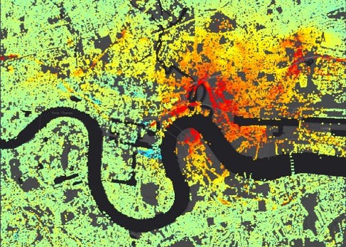
Interferometric Synthetic Aperture Radar (InSAR) is a family of techniques for processing satellite radar imagery in order to measure ground displacements. It can offer significant spatial coverage (orders of 1000 km2constrained only by processing time) thus potentially providing significant advantages (cost, time, coverage and accuracy) over more traditional techniques such as levelling and GPS.
InSAR is now widely used to characterize natural hazards such as earthquakes and volcanic eruptions, as well as human induced changes such as mine subsidence and aquifer drawdown. It is now possible to distinguish, for example, geological fault driven movement from aquifer recharge by separating both horizontal and vertical ground movements.
With nearly three decades of data, Persistent Scatterer Interferometry (PSI) is able to achieve sub-millimetre precision in displacement; analysis of long time-series data as part of the site investigation desk study can identify unusual patterns of displacement from past land use, e.g. cemeteries and historic landfill, and natural hazards such as faults and buried hollows.
However, analysis of InSAR and PSI data requires care and experience to identify causes of anomalies and eliminate artefacts.
Dr Richard Ghail is a Reader in Planetary and Engineering Geology at Royal Holloway, before which he spent most of the last decade in Civil Engineering at Imperial. He has worked with synthetic aperture radar (SAR) data for more than 25 years and understands its strangeness as an imaging system, and the use of its phase information for change detection. For the first time we now have a tool that can measure the rates of vertical and horizontal movement at the mm/yr level, characteristic of low seismicity continental interiors. He applies these techniques to help predict ground engineering problems and groundwater flow, and is developing new tools using the full amplitude, phase and polarimetric components of SAR data. Richard also leads a proposed mission to Venus, currently under study by ESA and NASA, to apply these techniques to better understand our closest planetary neighbour.